


C-Map Discover sjökort M-EN-Y205-MS Karlskrona-Emden
Det ursprungliga priset var: 1.890,00 kr.1.540,00 krDet nuvarande priset är: 1.540,00 kr.
C-Map sjökort över område Karlskrona – Marstrand – Danmark för Lowrance, Simrad och B&G med Easy Routing mm.
1-3 dagars leveranstid
C-Map sjökort över Kattegatt, Öresund och Södra Östersjön på MicroSD med SD korts adapter.

DISCOVER all you need to make the most of your time on the water. Full-featured Vector Charts with High-Res Bathy, including integrated Genesis® social data, subscription-free Easy Routing™ and Custom Depth Shading. See things your way with C-MAP.
CORE FEATURES
Every DISCOVER Chart Includes:
– Full Featured Vector Charts
– Tides & Currents
– Hi Res Bathymetry Layer
– Detailed Marina Port Plans
– Integrated Genesis Layer
– Custom Depth Shading
– 12 Months’ Free Updates
– Subscription-Free Easy Routing
FULL-FEATURED VECTOR CHARTS
Full-Featured Vector charts make navigation easy by giving you accurate, up-to-date vector chart detail derived from official Hydrographic Office information.

HI-RES BATHYMETRY LAYER
High-Res Bathymetry (HRB) Layer helps you identify shallow areas, drop offs, ledges, holes or humps by accurate contour lines down to 1-foot level of detail. Includes the very best of C-MAP HRB data, including C-MAP Team Lake Surveys (US only) and Genesis® social maps, quality controlled and fully integrated.

CUSTOM DEPTH SHADING
Custom Depth Shading allows you to set a safety depth, maintain a paper-like view or set your own custom shading – see things your way.

EASY ROUTING
Easy Routing helps you automatically plot the shortest, safest route based on detailed chart data and your personalized vessel information. With C-MAP Easy Routing is always subscription free.

TIDES & CURRENTS
Tides & Currents show projections of water level and direction of tides to help plan your day out, whether cruiting, angling or sailing.

DETAILED MARINA PORT PLANS
Docking in an unfamiliar port is no problem, when you have precise layouts of thousands of marinas, including slip spaces, restricted areas, and other valuable navigation information.

12 MONTHS’ FREE ONLINE UPDATES
Keep your chart up to date, with 12 months’ free online updates.
COMPATIBLE WITH B&G, SIMRAD AND LOWRANCE CHARTPLOTTERS
Check if DISCOVER is compatible with your Chartplotter.
| Vikt | 0,1 kg |
|---|
Relaterade produkter


RAM Ekolodsfäste / snabbfäste till Lowrance Elite/Hook/Mark 5-7″ skärm (C-KULA)


RAM Ekolodsfäste / snabbfäste till Lowrance Elite/Hook/Mark serien 3-5″ skärm (B-KULA)

RAM Ekolodsfäste universal till Humminbird, Lowrance, Raymarine & Garmin (D-KULA)


RAM Komplett ekolodsfäste universal till Humminbird, Lowrance & Garmin (C-KULA)

TR-120-KIT NMEA2000 Terminatorkit
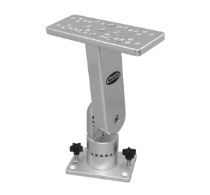
Traxstech ekolodsfäste enkelledad
Stabilt och kraftfullt ekolodsfäste från Traxstech. Tillverkat i eloxerat aluminium med livstids garanti. Tål att köras i saltvatten. Ekolodsfästet har en lyft- och vridbas som går att rotera i 360 grader. Det går även att justera upp och ner i 6 olika låsbara lägen ner till 90 graders vinkel. Ekolodsfästet har universal hålbild och passar de allra flesta ekolod på marknaden. Ekolodsfästet kan monteras i Traxstechs monteringsskena eller bultas/skruvas fast permanent. Det passar även i canons och berts custom tackles monteringsskena. Finns i tre olika längder. Välj längd nedan:


